| |
|
|
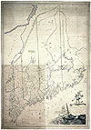
Maps help us to place people and events in relation to each other geographically. Martha Ballard lived in Hallowell, Maine. Explore the historical maps and views to see what cartographers in Martha's time knew about Maine and its surroundings.
|
|
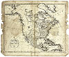 |
Without benefit of satellites or aerial photos, cartographers in 1795 could draw the Kennebec River on an outline map of North America that we recognize today.
|
|
|
Osgood Carleton made several detailed maps of Maine using local measurements and descriptions by surveyors like Ephraim Ballard. |
|
|
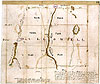
Ephraim Ballard served as one of the principal surveyors for the Kennebec Proprietors, who owned more than 600,000 acres in and around Hallowell. |
|
We have no pictures of Augusta or Hallowell as they looked during Martha Ballard's life, but Searle probably sketched this view only eleven years after Martha died.
|
|
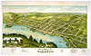 |
Engraved many years after Martha Ballard lived in Hallowell, Ruger's illustration nevertheless shows how the hills dropped down into the Kennebec River valley, leaving little or no flat ground.
|
|
||||||||||||||||||