DoHistoryWho Was Martha Ballard?Maps and Pictures site maptech helpabout sitesearch

  Map of the Parishes of Hallowell / Ephraim Ballard 1794


bullseye icon
click on a section of the map to enlarge.

remove grid


Ephraim Ballard was one of the principal surveyors for the Kennebec Proprietors, also known as the Plymouth Company. The Proprietors, who owned more than 600,000 acres of land along the Kennebec River, played a key role in founding the towns of Pownalboro, Gardinerstown, Hallowell, Winthrop, Vassalboro, and Winslow.

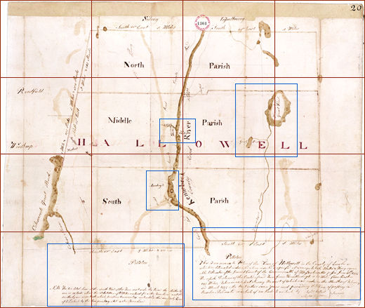
This map shows the few county roads and three church parishes of early Hallowell. In 1797, the North and Middle Parishes would split off and become the town of Augusta, partly because residents disagreed over where to bridge the Kennebec: at the Hook in the South Parish, or farther north at Fort Western. The bridge was built at Fort Western in 1797, a few months after the split.

Mr. Ballard drew this map on the same kind of paper that Martha Ballard cut and folded to make her diary.


Hallowell Map (clickable Image Map)


Maps and Plans (SC1, 150)
Plan of Hallowell, ME
1794 Series, Vol. 13 p. 20
#1361
Judicial Archives
Suffolk Files Collection
Moore v. the First Precinct of Rochester, MA

Courtesy of Massachusetts Archives
Massachusetts Archives at Columbia Point
220 Morrisey Blvd., Boston, MA 02125


Fort Western The Hook Woromontogus Great Pond Disputed Land Map Legend d4 d3 d2 d1 c4 c3 c2 c1 b4 b3 b2 b1 a4 a3 a2 a1
home your interests who was Martha? Martha's diary book film doing history archive on your own
maps & pictures | Martha Ballard timeline | walking tour